
Wednesday, 19 February, at 8.15pm in the Sheraton Hotel, Athlone
Talk by Dr Raoul McLaughlin
Summary At its zenith, the Roman Empire incorporated lands on three continents and ruled almost a fifth of the world’s ancient population. On every frontier the Roman Empire expanded until it reached vast desolate territories or further advance was halted by determined native resistance. The Romans conquered Iberia, Gaul and Britain, extending their Empire westward untilthey reached the island called Hibernia. But instead of imperial occupation, Ireland was able to remain on the frontiers of a conquered Europe during almost four centuries of Roman supremacy (AD 43-410). This lecture will discuss the various contacts between Ireland and Rome that took place during this era.
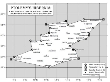
A reconstruction of Ptolemy’s map of Ireland (taken from ‘Ptolemy’s map of Ireland: a modern decoding’ by R. Darcy & William Flynn). Claudius Ptolemy was an Egyptian geographer and mathematician, who lived and worked in Alexandria. He created his map of Ireland around AD140.
Speaker Raoul McLaughlin studied Irish Archeology at Queen’s University Belfast and completed his doctorate in Ancient History in 2006. He published his monograph Rome and the Distant East (2010), The Roman Empire and the Indian Ocean (2014) and The Roman Empire and the Silk Routes (2016). He was a Tutor at Queen’s University Belfast until 2014. Raoul is currently an Independent Scholar working in a Clinical Care Home while he completes research on his next book Ancient Ireland and the Roman Empire. He is also co-authoring ‘Rome and China: Points of Contact’ with Dr Hyun Jin Kim and Professor Samuel Lieu.
